Map viewer/route logger for your outdoor activities!!
OruxMaps Donate
OruxMaps works in two modes:
- -online with many different types of maps (Google maps, OpenStreetMap, Microsoft Maps,etc.).
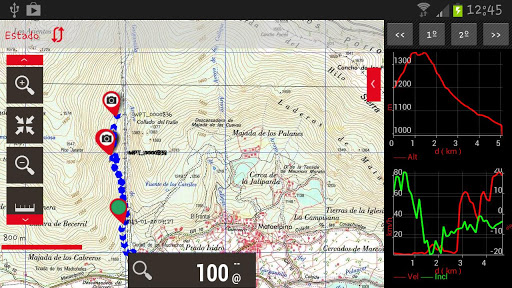
- -offline with calibrated maps for the application. You can convert your Ozi Explorer maps, or create your own maps, with a desktop tool.
Allows you record tracks using GPS. It works with gpx and kml formats.
Features:
- 100% free
100% no Advertising - Map download
- Text to Speech (some locales)
- Wms support
Support to some .rmap maps
Support to vector maps (mapsforge) - Profiles
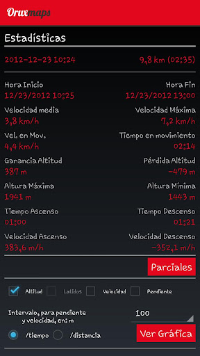
Save/restore preferences - Complete track statistics, with different graphs
- External bluetooth GPS support
- Export your tracks in KML/GPX formats
- Follow your old tracks/routes, with distance alarm.
- Save Waypoints with attached photo-audio-video media files. Wpt proximity alarm with custom audio alarm
- Waypoint navigation mode
- Geocaching support
- Custom cursor images
- Power save mode, for long track recording
- Use a heart monitor with your device (supported Zephyr HRM, Polar Bluetooth and ANT+)
- Upload/download tracks from everytrail.com
Upload tracks to gpsies.com, mapmytracks.com and trainingstagebuch.org
Live tracking with mapmytracks.com
What’s in this version :
- New ANT+ libraries.
- Now the sensors must be configured previously in configuration–sensors–ANT+ Use automatic search or introduce the ID by hand.
- Added battery status controls for dashboard.
- Added support to Bike power sensors.
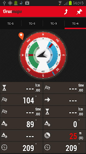
- New Dashboard controls
- New units for bearings (Mils)
- Change dashboard controls prioprity to stack them in different orden in map viewer (settings–user interface–dashboard)
- Bugs correction
Requires Android:2.0 and up